-40%
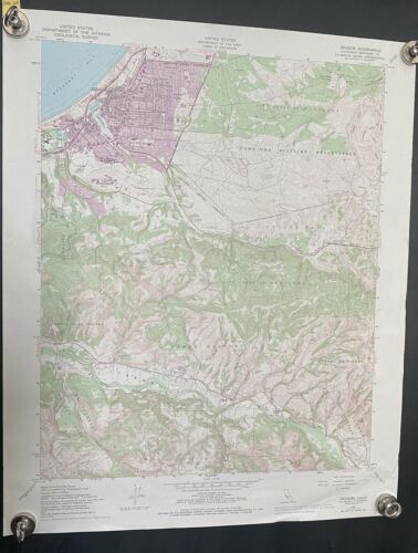
Vtg 1970 of 1947 Seaside Quadrangle Monterey CA Map 22" x 27” - 7.5 Min
$ 10.54
- Description
- Size Guide
Description
Vtg 1970 USGS Seaside Quadrangle Monterey CA Map 22" x 27” - 7.5 Minute SeriesThis is a 1947 Map, of the area - using 1927 North American Datum, printed in 1970
Maps shows Monterey Bay, Seaside, Noche Buena, El Protrero, Laguna Seca and more!
Condition is Preowned - some aging one small wrinkle on bottom right corner.
Upper left hand corner has a vintage tab that ID’s this map - see photo of this
This is an original USGS Topographic map printed in the year stated in the title.
This 1970 map is of the Seaside Quadrangle, California Monterey County.
This map would be ideal for historical reference or research, genealogy studies, collectors, would make a nice conversation piece, a gift for a history or map enthusiast, framing or display, or for anyone interested in the area.
See photos as these were taken for this listing
I will ship this rolled in a tube via Priority Mail
Ask any questions you have before purchasing
The post office continues to experience some delays, I ship same day IF possible and always next business day.
Thank you for looking.
